Burrowye, Granya and Walwa dingo predation management zone
Work plan 2025–26
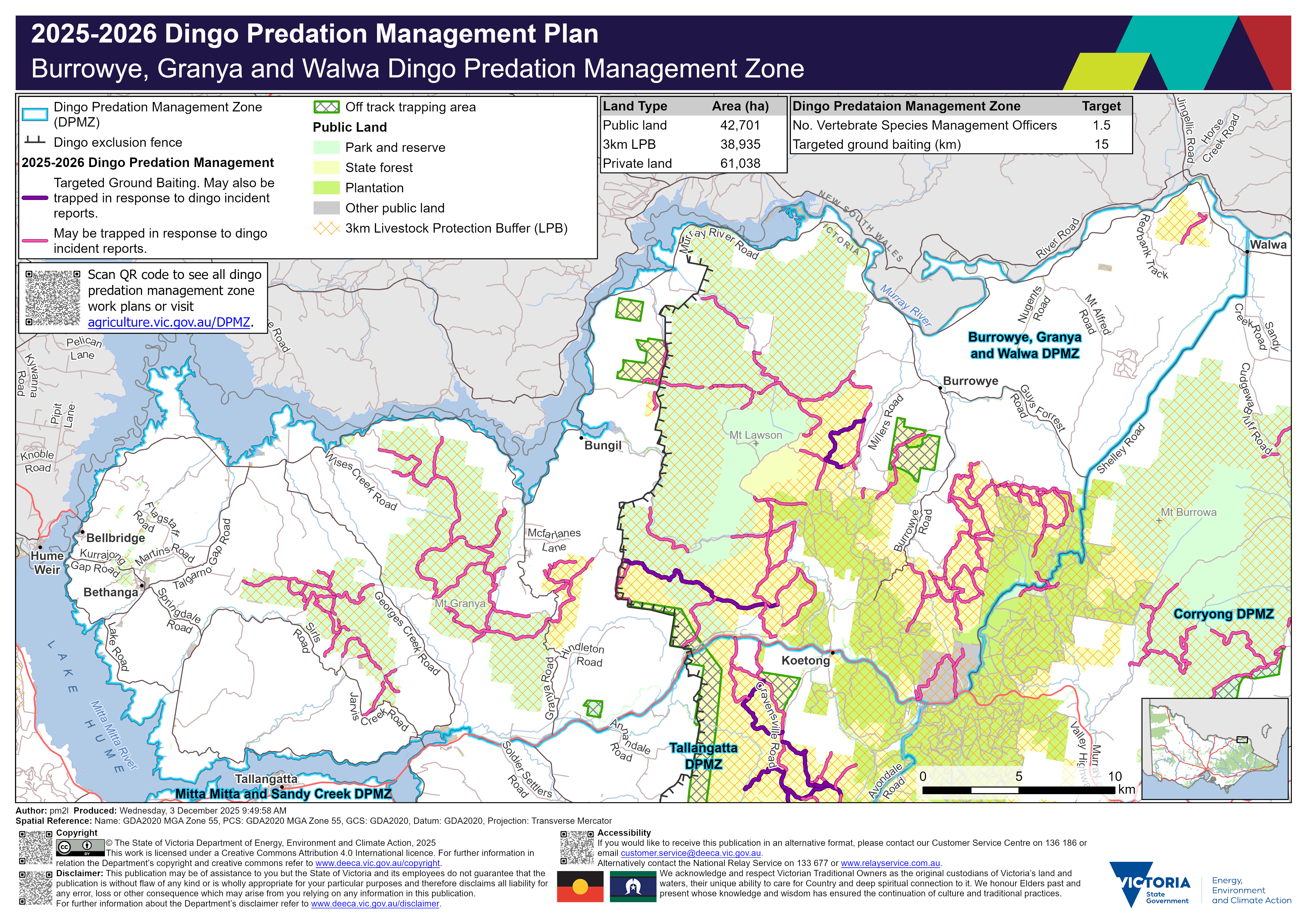
Burrowye, Granya and Walwa dingo predation management zone work plan map ![]() [PDF File - 2.5 MB]
[PDF File - 2.5 MB]
Legend
![]() Dingo Predation Management Zone (DPMZ)
Dingo Predation Management Zone (DPMZ)
2025-2026 Dingo Predation Management
![]() Targeted Ground Baiting. May also be trapped in response to dingo incident reports
Targeted Ground Baiting. May also be trapped in response to dingo incident reports
![]() May be trapped in response to dingo incident reports
May be trapped in response to dingo incident reports
![]() Off track ground baiting and trapping area
Off track ground baiting and trapping area
![]() Off track trapping area
Off track trapping area
Community Vertebrate Species Control (CVSC)
![]() CVSP group
CVSP group
![]() Dingo exclusion fence
Dingo exclusion fence
Public Land
![]() Park and reserve
Park and reserve
![]() State forest
State forest
![]() Plantation
Plantation
![]() Other public land
Other public land
![]() Port and coastal facility
Port and coastal facility
![]() Marine park or reserve
Marine park or reserve
![]() Water body
Water body
![]() 3km Livestock Protection Buffer (LPB)
3km Livestock Protection Buffer (LPB)
Details
Localities within the Burrowye, Granya and Walwa dingo predation management zone include:
- Bellbridge
- Bethanga
- Bullioh
- Bungil
- Burrowye
- Georges Creek
- Granya
- Guys Forest
- Huon
- Jarvis Creek
- Koetong
- Mount Alfred
- Old Tallangatta
- Shelley
- Talgarno
- Tallangatta
- Tallangatta East
- Tallangatta Valley
- Thologolong
- Walwa.
Trapping activities in response to dingo related incident reports can be undertaken on the majority of tracks on public land within 3 km of the private land and public land interface surrounding the above mentioned localities.
Targeted ground-baiting transects are located on public land:
- south east of Bungil
- west of Burrowye
- north west of Koetong.
Within the Burrowye, Granya and Walwa dingo predation management zone there is 42,701 hectares of public land, 38,935 hectares of land under the 3 km livestock protection buffer and 61,038 of private land. There are 2 Vertebrate Species Management Officers, and 15 km of targeted ground baiting transects.
The map should be read in conjunction with the accompanying Burrowye, Granya and Walwa dingo predation management zone plan.
If you would like to receive this information in an accessible format, please phone 136 186, email customer.service@deeca.vic.gov.au, or via the Access Hub.