Gembrook, Noojee and Erica dingo predation management zone
Work plan 2026–27
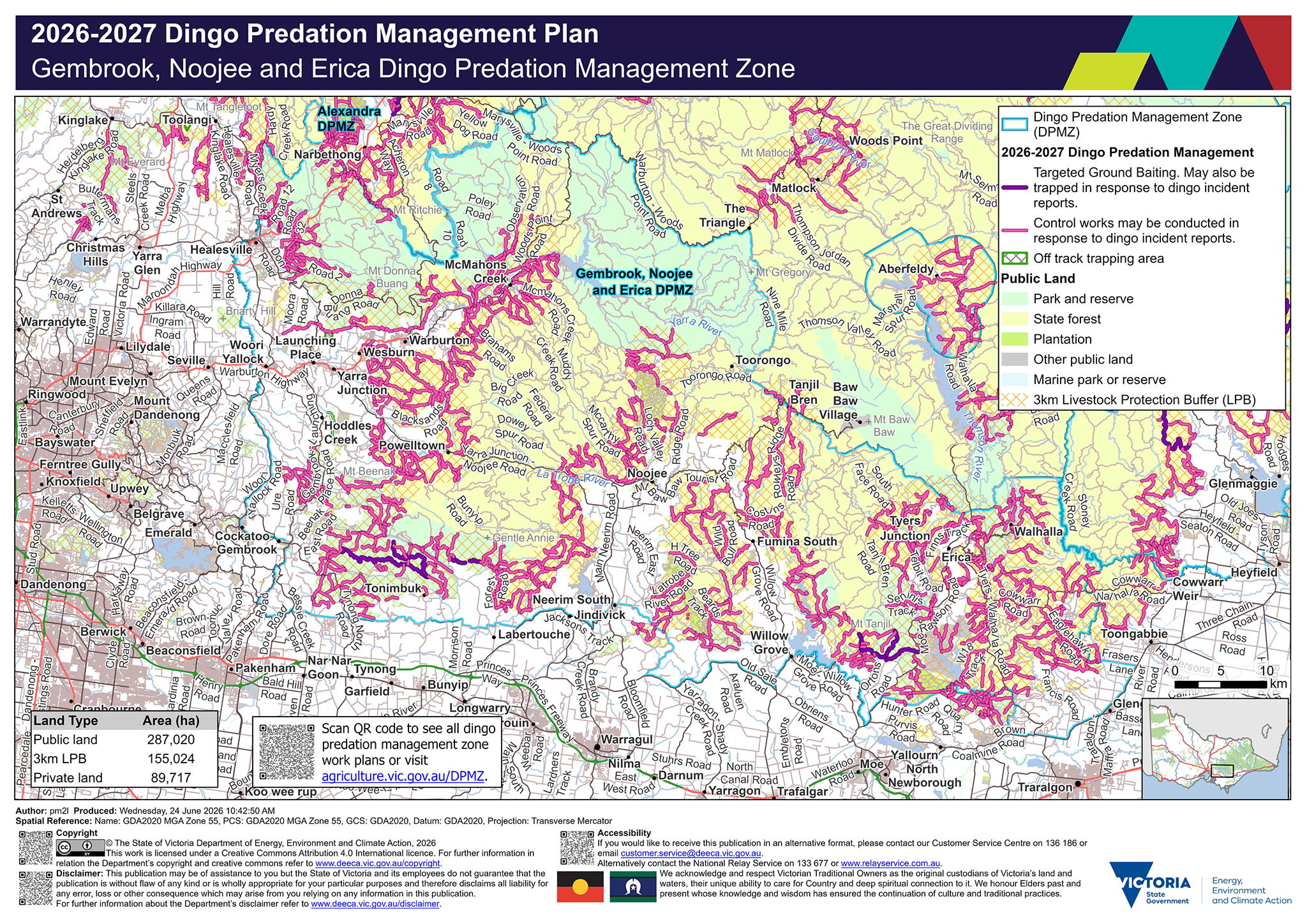
Legend
![]() Dingo Predation Management Zone (DPMZ)
Dingo Predation Management Zone (DPMZ)
2025-2026 Dingo Predation Management
![]() Targeted Ground Baiting. May also be trapped in response to dingo incident reports
Targeted Ground Baiting. May also be trapped in response to dingo incident reports
![]() May be trapped in response to dingo incident reports
May be trapped in response to dingo incident reports
![]() Off track ground baiting and trapping area
Off track ground baiting and trapping area
![]() Off track trapping area
Off track trapping area
Community Vertebrate Species Control (CVSC)
![]() CVSP group
CVSP group
![]() Dingo exclusion fence
Dingo exclusion fence
Public Land
![]() Park and reserve
Park and reserve
![]() State forest
State forest
![]() Plantation
Plantation
![]() Other public land
Other public land
![]() Port and coastal facility
Port and coastal facility
![]() Marine park or reserve
Marine park or reserve
![]() Water body
Water body
![]() 3km Livestock Protection Buffer (LPB)
3km Livestock Protection Buffer (LPB)
Details
Localities within the Gembrook, Noojee and Erica dingo predation management zone include:
- Aberfeldy
- Ada
- Amor
- Avonsleigh
- Badger Creek
- Baw Baw
- Beenak
- Big Pats Creek
- Boola
- Buln Buln East
- Cambarville
- Caringal
- Cockatoo
- Coldstream
- Coopers Creek
- Don Valley
- East Warburton
- Erica
- Fernshaw
- Fumina
- Fumina South
- Garfield North
- Gembrook
- Gentle Annie
- Gilderoy
- Gladysdale
- Glengarry
- Glengarry North
- Glengarry West
- Gruyere
- Healesville
- Hill End
- Hoddles Creek
- Icy Creek
- Jacob Creek
- Jericho
- Jindivick
- Labertouche
- Launching Place
- Loch Valley
- Maryknoll
- Marysville
- McMahons Creek
- Millgrove
- Moondarra
- Mount Burnett
- Mount Toolebewong
- Nangana
- Nar Nar Goon North
- Narbethong
- Nayook
- Neerim
- Neerim East
- Neerim Junction
- Neerim North
- Neerim South
- Noojee
- Pakenham Upper
- Piedmont
- Powelltown
- Rawson
- Reefton
- Seville
- Seville East
- Shady Creek
- Tanjil
- Tanjil Bren
- Tanjil South
- Thalloo
- Thomson (Mount Baw Baw)
- Three Bridges
- Tonimbuk
- Toolangi
- Toombon
- Toongabbie
- Toorongo
- Trafalgar
- Tyers
- Tynong North
- Vesper
- Walhalla
- Warburton
- Wesburn
- Willow Grove
- Woori Yallock
- Yallourn North
- Yarra Junction
- Yellingbo
Trapping activities in response to dingo related incident reports can be undertaken on the majority of tracks on public land within 3 km of the private land and public land interface surrounding the above mentioned localities.
Targeted ground-baiting transects are located on public land:
- east of Gembrook
- north and north-east of Tonimbuk
- east of Willow Grove
- south-west of Erica
- west of Toongabbie
The map shows within the Gembrook, Noojee and Erica dingo predation management zone there is 287,020 hectares of public land, 155,024 hectares of land under the 3 km livestock protection buffer and 89,717 hectares of private land.
If you would like to receive this information in an accessible format, please phone 136 186, email customer.service@deeca.vic.gov.au, or via the Access Hub.