Mansfield dingo predation management zone
Work plan 2026–27
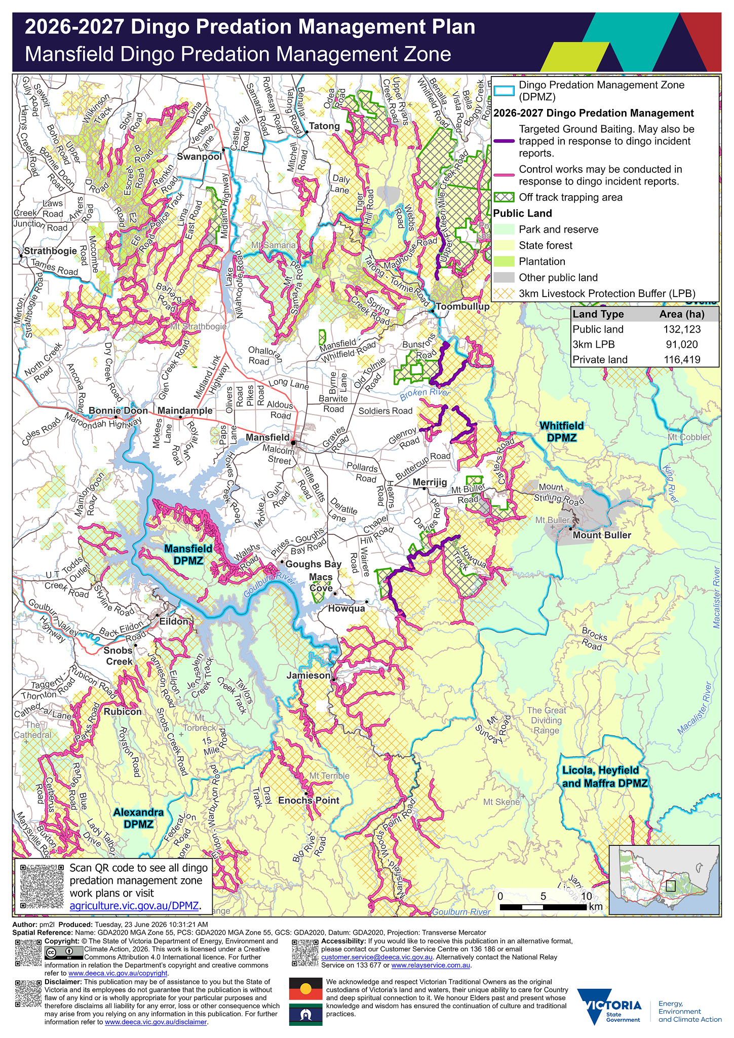
View a larger version of the Mansfield dingo predation management zone map [Image - 3.5 MB]
Legend
 Dingo Predation Management Zone (DPMZ)
2025-2026 Dingo Predation Management
 Targeted Ground Baiting. May also be trapped in response to dingo incident reports
 May be trapped in response to dingo incident reports
 Off track ground baiting and trapping area
 Off track trapping area
Community Vertebrate Species Control (CVSC)
 CVSP group
 Dingo exclusion fence
Public Land
 Park and reserve
 State forest
 Plantation
 Other public land
 Port and coastal facility
 Marine park or reserve
 Water body
 3km Livestock Protection Buffer (LPB)
Details
Localities within the Mansfield dingo predation management zone include:
- Ancona
- Archerton
- Barjarg
- Barwite
- Bonnie Doon
- Boorolite
- Bridge Creek
- Creek Junction
- Delatite
- Eildon
- Enochs Point
- Goughs Bay
- Howes Creek
- Howqua
- Howqua Hills
- Howqua Inlet
- Jamieson
- Kevington
- Knockwood
- Lake Eildon
- Lima
- Lima East
- Lima South
- Macs Cove
- Maindample
- Mansfield
- Merrijig (Mount Buller)
- Merton
- Mirimbah
- Mount Buller
- Mountain Bay
- Myrrhee
- Piries
- Sawmill Settlement
- Strathbogie
- Swanpool
- Tatong
- Tolmie
- Woodfield.
Trapping activities in response to dingo related incident reports can be undertaken on the majority of tracks on public land within 3 km of the private land and public land interface surrounding the above mentioned localities.
Targeted ground-baiting transects are located on public land:
- east of Mansfield
- north and south of Toombullup
- north and south of Merrijig
- east of Howqua.
The map shows within the Mansfield dingo predation management zone there is 132,123 hectares of public land, 91,020 hectares of land under the 3 km livestock protection buffer and 116,419 hectares of private land.
If you would like to receive this information in an accessible format, please phone 136 186, email customer.service@deeca.vic.gov.au, or via the Access Hub.