Omeo, Swifts Creek and Benambra dingo predation management zone
Work plan 2026–27
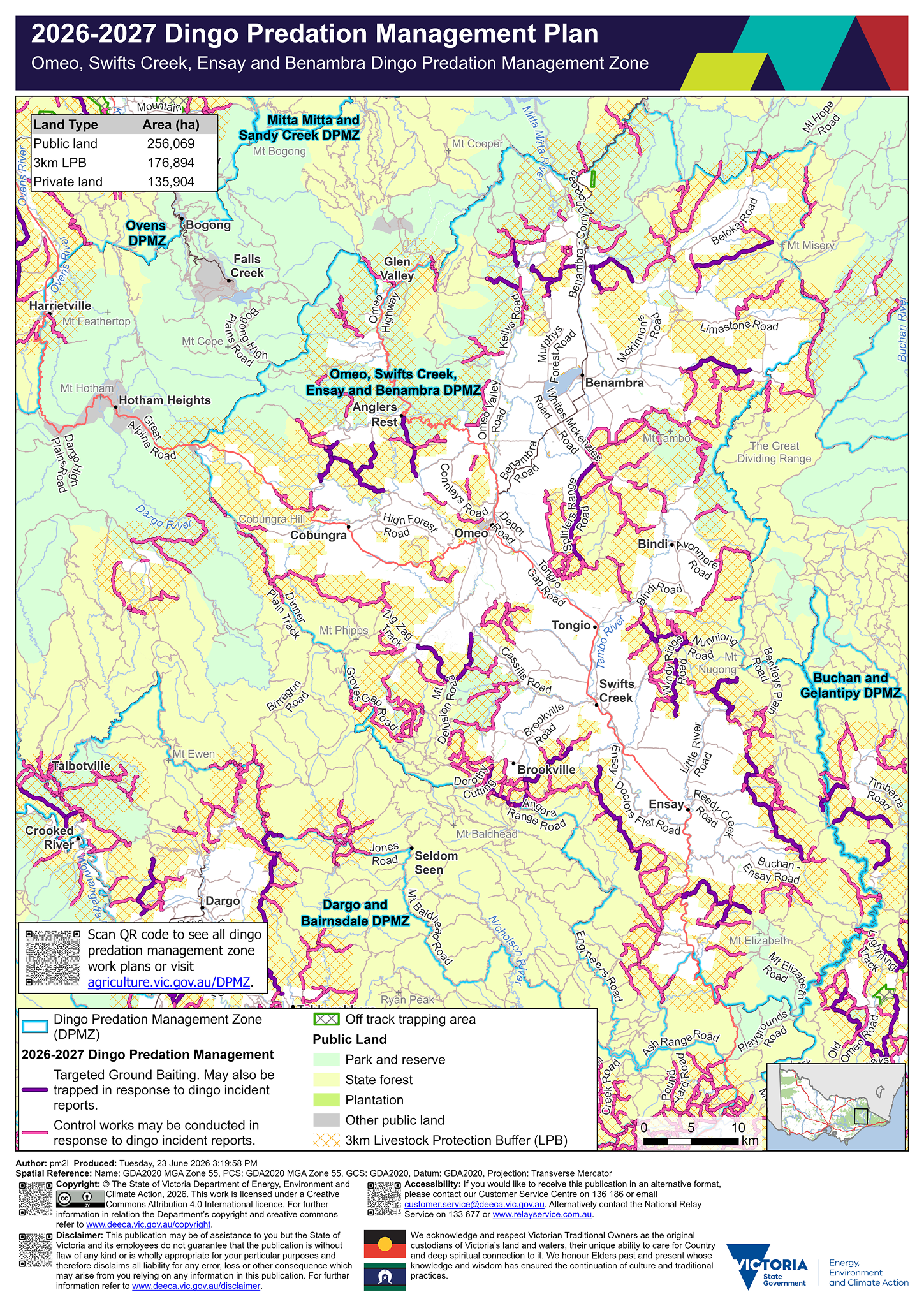
Legend
![]() Dingo Predation Management Zone (DPMZ)
Dingo Predation Management Zone (DPMZ)
2025-2026 Dingo Predation Management
![]() Targeted Ground Baiting. May also be trapped in response to dingo incident reports
Targeted Ground Baiting. May also be trapped in response to dingo incident reports
![]() May be trapped in response to dingo incident reports
May be trapped in response to dingo incident reports
![]() Off track ground baiting and trapping area
Off track ground baiting and trapping area
![]() Off track trapping area
Off track trapping area
Community Vertebrate Species Control (CVSC)
![]() CVSP group
CVSP group
![]() Dingo exclusion fence
Dingo exclusion fence
Public Land
![]() Park and reserve
Park and reserve
![]() State forest
State forest
![]() Plantation
Plantation
![]() Other public land
Other public land
![]() Port and coastal facility
Port and coastal facility
![]() Marine park or reserve
Marine park or reserve
![]() Water body
Water body
![]() 3km Livestock Protection Buffer (LPB)
3km Livestock Protection Buffer (LPB)
Details
Localities within the Omeo, Swifts Creek and Benambra dingo predation management zone include:
- Anglers Rest
- Benambra
- Bindi
- Bingo Munjie
- Brookville
- Brumby
- Buchan
- Buchan South
- Bundara
- Cassilis
- Cobberas
- Cobungra
- Dargo
- Dartmouth
- Deptford
- Dinner Plain
- Doctors Flat
- Double Bridges
- Ensay
- Ensay North
- Glen Valley
- Glen Wills
- Hinnomunjie
- Hotham Heights
- Mitta Mitta
- Nariel Valley
- Nelse
- Nunniong
- Omeo
- Omeo Valley
- Reedy Flat
- Shannonvale
- Stirling
- Swifts Creek
- Tambo Crossing
- Timbarra
- Tongio
- Wentworth
Trapping activities in response to dingo related incident reports can be undertaken on the majority of tracks on public land within 3 km of the private land and public land interface surrounding the above mentioned localities.
Targeted ground-baiting transects are located on public land:
- north, east and south of Benambra
- south of Anglers Rest
- north of Cobungra
- south-east of Bindi
- east and west of Tongio
- north-east and south-west of Swifts Creek
- surrounding Ensay
- east, south and west of Brookville.
Within the Omeo, Swifts Creek, Ensay and Benambra dingo predation management zone there is 256,069 hectares of public land, 176,894 hectares of land under the 3 km livestock protection buffer and 135,904 hectares of private land.
There are three community Vertebrate Species control groups located within the Omeo, Swifts Creek and Ensay dingo predation management zone. The Omeo and Benambra Community Vertebrate Species Control group includes private land near Cobungra, Omeo and Benambra. The Swifts Creek Community Vertebrate Species Control groups include private land near Bindi, Tongio, Swifts Creek and Brookville. The Ensay Community Vertebrate Species Control group includes private land near Ensay and Tambo Crossing.
If you would like to receive this information in an accessible format, please phone 136 186, email customer.service@deeca.vic.gov.au, or via the Access Hub.