Orbost and Cann River dingo predation management zone
Work plan 2026–27
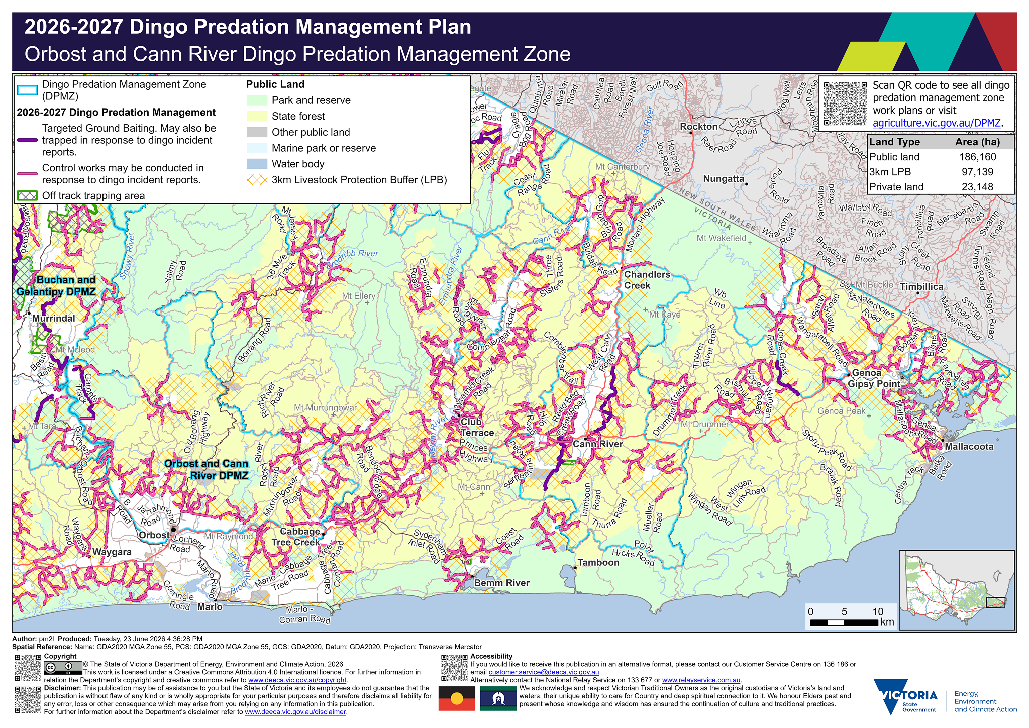
Legend
![]() Dingo Predation Management Zone (DPMZ)
Dingo Predation Management Zone (DPMZ)
2025-2026 Dingo Predation Management
![]() Targeted Ground Baiting. May also be trapped in response to dingo incident reports
Targeted Ground Baiting. May also be trapped in response to dingo incident reports
![]() May be trapped in response to dingo incident reports
May be trapped in response to dingo incident reports
![]() Off track ground baiting and trapping area
Off track ground baiting and trapping area
![]() Off track trapping area
Off track trapping area
Community Vertebrate Species Control (CVSC)
![]() CVSP group
CVSP group
![]() Dingo exclusion fence
Dingo exclusion fence
Public Land
![]() Park and reserve
Park and reserve
![]() State forest
State forest
![]() Plantation
Plantation
![]() Other public land
Other public land
![]() Port and coastal facility
Port and coastal facility
![]() Marine park or reserve
Marine park or reserve
![]() Water body
Water body
![]() 3km Livestock Protection Buffer (LPB)
3km Livestock Protection Buffer (LPB)
Details
Localities within the Orbost and Cann River dingo predation management zone include:
- Bendoc
- Bete Bolong
- Bete Bolong North
- Brodribb River
- Buldah
- Cabbage Tree Creek
- Cann River
- Chandlers Creek
- Club Terrace
- Combienbar
- Genoa
- Gipsy Point
- Jarrahmond
- Mallacoota
- Maramingo Creek
- Newmerella
- Noorinbee
- Noorinbee North
- Nurran
- Orbost
- Tamboon
- Tonghi Creek
- Wallagaraugh
- Wangarabell
- Wroxham
- Yalmy.
Trapping activities in response to dingo related incident reports can be undertaken on the majority of tracks on public land within 3 km of the private land and public land interface surrounding the above mentioned localities.
Targeted ground-baiting transects are located on public land:
- north-east and south-west of Cann River
- west of Genoa.
The map shows within the Orbost and Cann River dingo predation management zone there is 186,160 hectares of public land, 97,139 hectares of land under the 3 km livestock protection buffer and 23,148 hectares of private land. There is one Vertebrate Species Management Officer and 26 km of targeted ground-baiting transects.
If you would like to receive this information in an accessible format, please phone 136 186, email customer.service@deeca.vic.gov.au, or via the Access Hub.