Ovens dingo predation management zone
Work plan 2025–26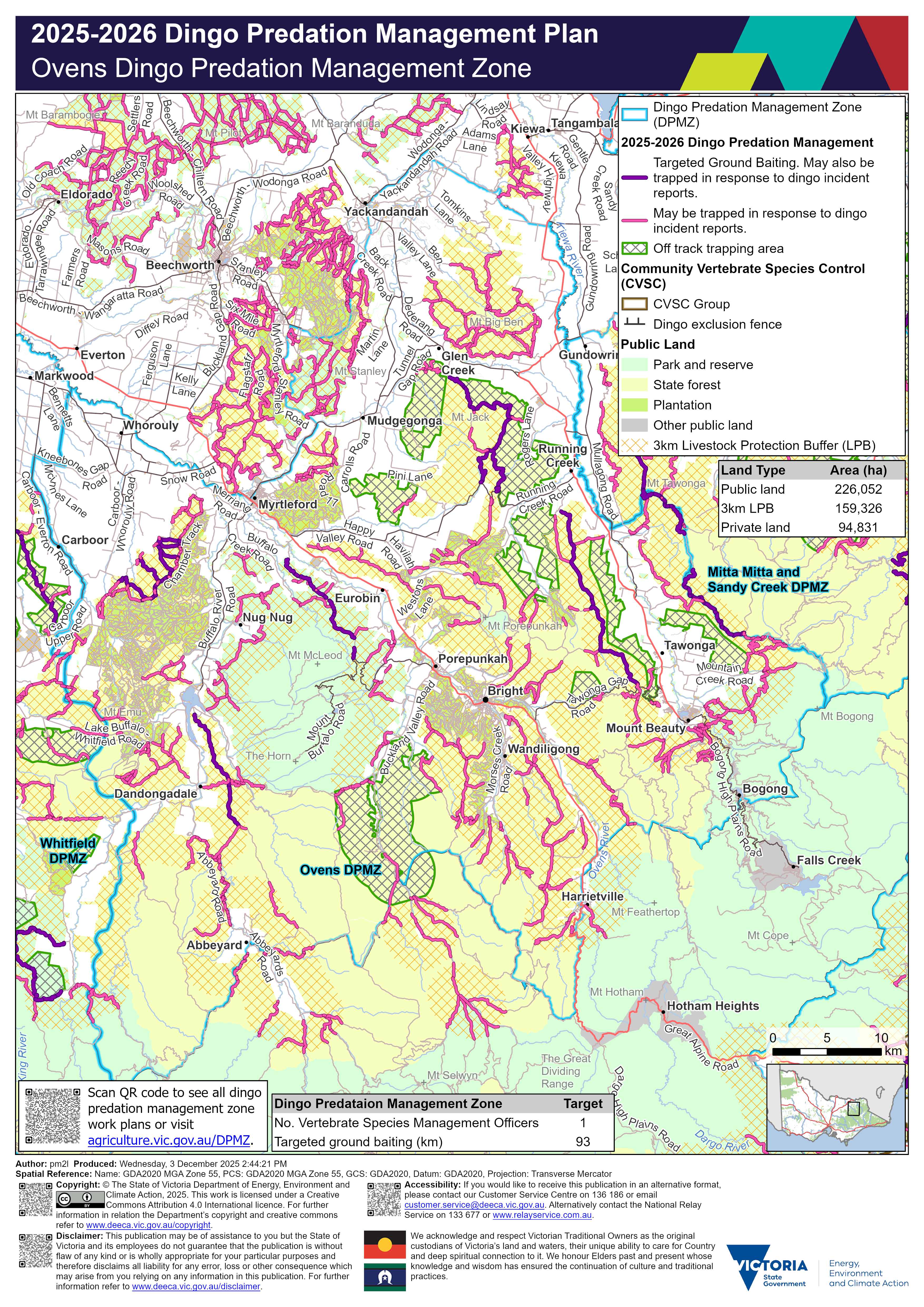
Ovens dingo predation management zone work plan document and map ![]() [PDF File - 4.5 MB]
[PDF File - 4.5 MB]
Legend
![]() Dingo Predation Management Zone (DPMZ)
Dingo Predation Management Zone (DPMZ)
2025-2026 Dingo Predation Management
![]() Targeted Ground Baiting. May also be trapped in response to dingo incident reports
Targeted Ground Baiting. May also be trapped in response to dingo incident reports
![]() May be trapped in response to dingo incident reports
May be trapped in response to dingo incident reports
![]() Off track ground baiting and trapping area
Off track ground baiting and trapping area
![]() Off track trapping area
Off track trapping area
Community Vertebrate Species Control (CVSC)
![]() CVSP group
CVSP group
![]() Dingo exclusion fence
Dingo exclusion fence
Public Land
![]() Park and reserve
Park and reserve
![]() State forest
State forest
![]() Plantation
Plantation
![]() Other public land
Other public land
![]() Port and coastal facility
Port and coastal facility
![]() Marine park or reserve
Marine park or reserve
![]() Water body
Water body
![]() 3km Livestock Protection Buffer (LPB)
3km Livestock Protection Buffer (LPB)
Details
Localities within the Ovens dingo predation management zone include:
- Abbeyard
- Allans Flat
- Barwidgee
- Bobinawarrah
- Bogong
- Bowmans Forest
- Bright
- Bruarong
- Buckland
- Buffalo River
- Carboor
- Coral Bank
- Dandongadale
- Dederang
- Edi Upper
- Eskdale
- Eurobin
- Everton
- Falls Creek
- Freeburgh
- Gapsted
- Germantown
- Glen Creek
- Gundowring
- Harrietville
- Havilah
- Hotham Heights
- Kancoona
- Kergunyah
- Kergunyah South
- Kiewa
- Markwood
- Merriang
- Merriang South
- Mitta Mitta
- Mongans Bridge
- Mount Beauty
- Mount Buffalo
- Mudgegonga
- Myrtleford
- Nelse
- Nug Nug
- Osbornes Flat
- Ovens
- Porepunkah
- Rose River
- Rosewhite
- Running Creek
- Selwyn
- Smoko
- Stanley
- Tawonga
- Tawonga South
- Upper Gundowring
- Wabonga
- Wandiligong
- Whorouly
- Whorouly East
- Whorouly South
- Yackandandah.
Trapping activities in response to dingo related incident reports can be undertaken on the majority of tracks on public land within 3 km of the private land and public land interface surrounding the above mentioned localities.
Targeted ground-baiting transects are located on public land:
- between Mudgegonga and Running Creek
- east of Carboor
- west of Eurobin
- east of Running Creek
- east and west of Tawonga
- north-east, east and south-east of Dandongadale
Within the Ovens dingo predation management zone there is 226,052 hectares of public land, 159,326 hectares of land under the 3 km livestock protection buffer and 94,831 hectares of private land. There is one Vertebrate Species Management Officer and 93 km of targeted ground baiting transects.
The map should be read in conjunction with the accompanying Ovens dingo predation management zone plan.
If you would like to receive this information in an accessible format, please phone 136 186, email customer.service@deeca.vic.gov.au, or via the Access Hub.