Ovens wild dog management zone
Work plan 2023–2024
Ovens wild dog management zone work plan document and map (PDF - 3.8 MB)
Localities within the Ovens wild dog management zone include:
- Abbeyard
- Allans Flat
- Barwidgee
- Bobinawarrah
- Bogong
- Bowmans Forest
- Bright
- Bruarong
- Buckland
- Buffalo River
- Carboor
- Coral Bank
- Dandongadale
- Dederang
- Edi Upper
- Eskdale
- Eurobin
- Everton
- Falls Creek
- Freeburgh
- Gapsted
- Germantown
- Glen Creek
- Gundowring
- Harrietville
- Havilah
- Hotham Heights
- Kancoona
- Kergunyah
- Kergunyah South
- Kiewa
- Markwood
- Merriang
- Merriang South
- Mitta Mitta
- Mongans Bridge
- Mount Beauty
- Mount Buffalo
- Mudgegonga
- Myrtleford
- Nelse
- Nug Nug
- Osbornes Flat
- Ovens
- Porepunkah
- Rose River
- Rosewhite
- Running Creek
- Selwyn
- Smoko
- Stanley
- Tawonga
- Tawonga South
- Upper Gundowring
- Wabonga
- Wandiligong
- Whorouly
- Whorouly East
- Whorouly South
- Yackandandah.
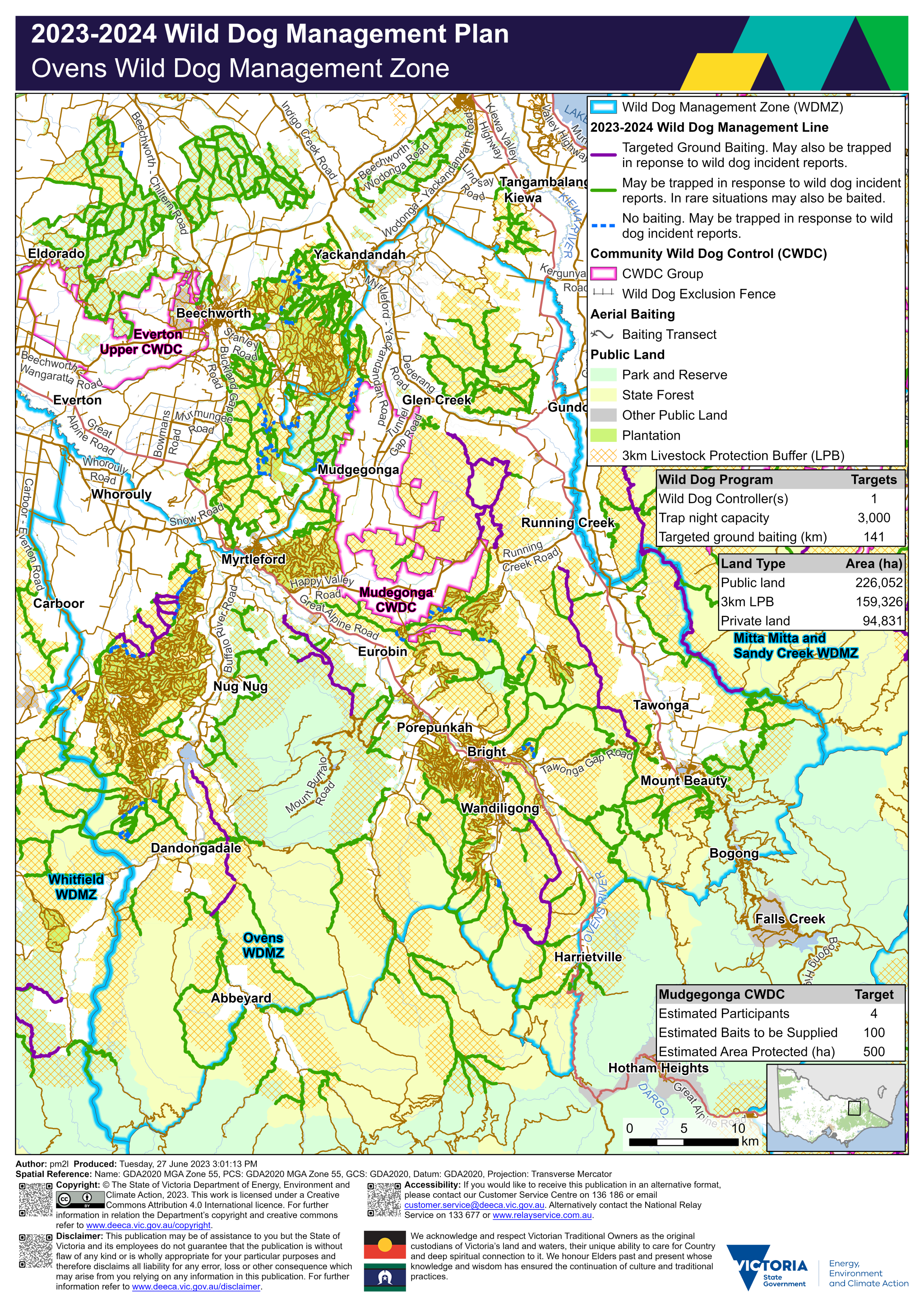
Targeted ground baiting transects are located on public land:
- between Mudgegonga and Running Creek
- east of Carboor
- west of Eurobin
- east of Running Creek
- east and west of Towonga
- north-east, east and south-east of Dandongadale
- between Wandiligong and Harrietville.
Trapping and Priority 2 Ground Baiting transects are a network of tracks. These are located on public land:
- east of Eldorado
- east and south-east of Beechworth
- north-east, south-west and west of Yackandandah
- south of Kiewa
- north-east and south of Glen Creek
- west of Mudgegonga
- west of Whorouly
- north, south and west of Myrtleford
- east of Running Creek
- surrounding Nug Nug, Dandongadale, Abbeyard, Eurobin, Porepunkah, Bright, Wandiligon, Harrietville, Tawonga and Mount Beauty.
The map shows within the Ovens wild dog management zone there is 226,052 hectares of public land, 159,326 hectares of land under the three-kilometre livestock protection buffer and 94,831 of private land. There is one Wild Dog Controller, with a capacity for 3,000 trap nights and 151 kilometres of targeted ground baiting transects.
There are three Community Wild Dog Control groups located within or adjoining the Ovens wild dog management zone. The Everton Upper Community Wild Dog Control group includes private land near Beechworth. The Carboor and Whorouly Community Wild Dog Control group includes private land near Carboor, Whorouly and Myrtleford. The Mudgegonga Community Wild Dog Control group includes private land near Glen Creek and Mudgegonga.
The map should be read in conjunction with the accompanying Ovens wild dog management zone plan.
If you would like to receive this publication in an accessible format, please phone 136 186 or email customer.service@dewlp.vic.gov.au, or via the National Relay Service on 133 677.