Information Notes (Victorian Mallee)
Monitoring wind erosion and land management in the Victorian Mallee – 2022 season
You can also download a PDF version of this information note ![]() [PDF File - 420.8 KB]
[PDF File - 420.8 KB]
Agriculture Victoria, with support from the Mallee Catchment Management Authority (CMA), is monitoring wind erosion risk in the Victorian Mallee by assessing ground cover and land management throughout the year. This work contributes to the understanding of how the region is maintaining ground cover and reducing the effects of wind erosion. Ground cover data is obtained through remote sensing (satellite imagery) technology and roadside surveys.
Since 2019, two roadside surveys have been undertaken each year across the Mallee CMA region during autumn and spring to collect ground cover and land management information allowing trends over time to be identified. Crop type data is also derived from satellite imagery to assess the total vegetative cover (TVC). Satellite imagery allows the entire Mallee CMA region to be measured repeatedly and efficiently.

Figure 1 is an image derived by remote sensing of the Mallee catchment displaying large areas of public land, that are national parks, as the darkest shapes on the western border. The image shows cereals as the lightest shades and were the dominant land cover, covering 70.8% of agricultural land and being more abundant in the north and less in the central regions. The darker shades represent legumes that covered 21.8% of agricultural land and were more abundant in the south. Canola (oilseeds) less than 0.2% of agricultural land and more abundant in the south and 1.2% of the region was bare.

Figure 2 is a graph that shows 6 pillars (Bare, Cereal, Legume, Oilseed, Pasture, Stubble) with 4 columns in each for the last 4 years. The darkest column (2022) is labelled with the number of paddocks found in the Spring survey. The 2022 spring roadside survey observed paddocks with primary land cover types (Figure 2). Results were similar to the regional satellite-derived crop cover data highlighting a decrease in cereals for the fourth consecutive year, the highest number of paddocks sown to legumes in four years, and an increase in oilseeds. The roadside survey also recorded a decrease in pasture and stubble from the previous year and no bare paddocks.
A key component of the spring roadside survey is crop management data (Figure 3). The spring survey was undertaken at the end of September into October 2022.
This survey estimated that 78.1% of crops would be harvested and 3.6% were hay crops. Brown or green manures made up 2.8% and undetermined crops made up 2% of surveyed paddocks and are those that are unable to be assigned. There were no failed crops in 2022 in the survey.

Figure 3 is a bar graph that shows each of the management types surveyed (Harvest, cut for hay, failed, grazed, brown/green manure, fallows and undetermined). The majority of crops would be harvested and there were no failed crops in spring 2022.
Key Messages
Favourable seasonal conditions are conducive to high levels of ground cover and is one of the drivers that influences crop selection and management practices on farm. Many farmers are striving to retain ground cover despite weather conditions, through actions such as growing ryecorn or lupins on dune crests alongside vetch hay or cereals on the swales or modifying sowing practices to maximise biomass when cutting for hay.
Other underlying factors, such as location and soil properties also affect the level of ground cover and thus inherent susceptibility to wind erosion. The Mallee CMA region has 13 land systems with each assigned a susceptibility rating of 'very high’, ‘high’, ‘moderate', ‘low’ or ‘very low’.
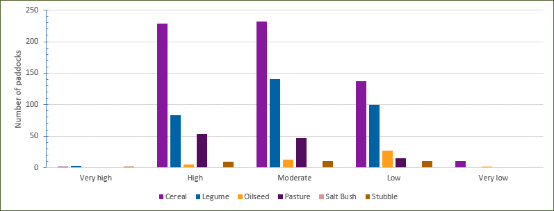
Most legumes are grown in the ‘moderate’ and ‘low’ susceptibility zones (Figure 4). Harvesting legumes or cutting hay, particularly in ‘high’ susceptibility zones, increases the risk of wind erosion as crops are cut lower to the ground to collect maximum biomass. Care at crop selection and at harvest is required when growing legumes in ‘high’ and ‘very high’ susceptibility zones.
Vegetation (both growing and dead) which covers more than 50% of an area provides good protection from wind erosion. This threshold is used to compare different areas and years to monitor wind erosion risk.
Even though the increase in legumes presented a higher risk of wind erosion in 2022, annual and growing season rainfall across the Mallee was higher than average, which promoted vegetation growth. In general, TVC was higher than 50% for longer periods of time, and across a greater area in 2022 compared with the three previous years.
Favourable weather increases vegetative growth, however best practice management by farmers is key to retaining ground cover regardless of the seasonal conditions. Crop selection, appropriate location, stubble retention and height, and controlled grazing, all contribute to reducing the risk of wind erosion in the Mallee.

Figure 4 is a graph showing 5 pillars (very high, high, moderate, low, very low) representing each of the susceptibility zones, with 6 columns each representing each of the primary cover types (cereals, legumes, oilseed, pasture, salt bush, stubble). The graph highlights the number of paddocks in which susceptibility zone each of the cover types were found in the survey.
This project is supported by Mallee Catchment Management Authority, through funding from the Australian Government’s National Landcare Program, in partnership with Agriculture Victoria.